OPS Network™ × Critical Response Group

One Operational PictureCRG Mapping

One map. One picture. Every agency on the same page.

Collaborative Response Graphics® from Critical Response Group integrate into OPS Schools & Structures, Community Cameras, and HUB mapping — so partner agencies see CRG maps, cameras, ALPRs, and OPS icons together in a single operating picture.

Critical Response Group

America’s Common Operating Picture® — critical incident mapping built for responders under stress.

Visit CRGPlans.com →

Common Operating Picture

Everyone sees the same complete picture.

In OPS, agencies do not bounce between separate map tools. CRG graphics, community cameras, government cameras such as ALPRs, and OPS featured mapping icons layer into one shared view — so command, field units, and partner agencies speak the same location language.

CRG maps

Collaborative Response Graphics® with site grids, room labels, access points, and critical infrastructure markers.

Community cameras

Public and partner camera locations plotted on the same canvas responders already use for CRG navigation.

Government cameras

Agency and government assets — including ALPRs — visible in context with structures and response graphics.

OPS map icons

OPS featured mapping icons that highlight mission-critical points across the network’s shared picture.

Inside OPS

Micro overlays and 3D floors — same campus, same picture.

OPS Schools and Structures with a CRG MACRO campus map, cameras, ALPRs, and a school list
Schools & Structures CRG floor plan on the live campus map — cameras, exits, and facility icons, OPS icons, area residential/commercial cameras and ALPR's all in one view.
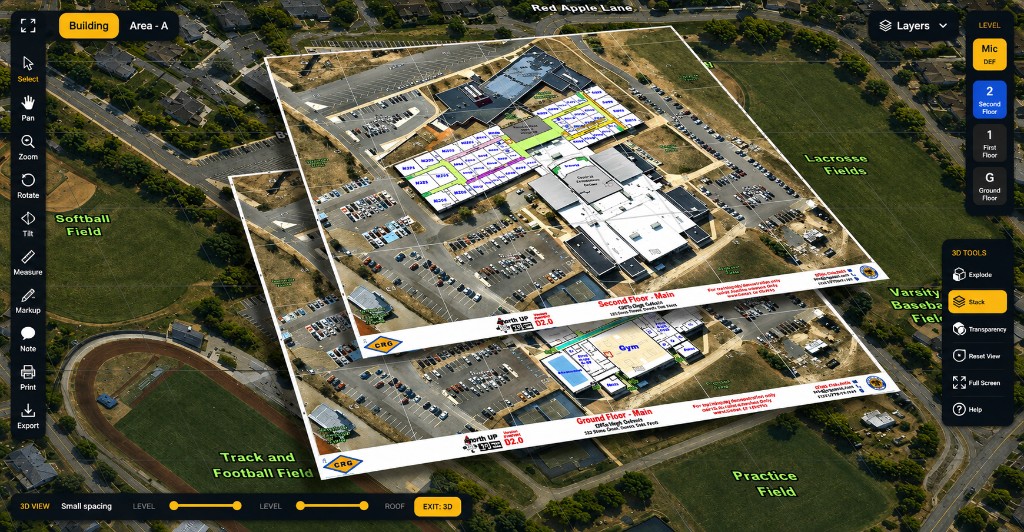
OPS 3D View showing stacked CRG floor layers over a campus
3D View Stacked CRG floor layers over the site — navigate levels without leaving the operating picture.

Where CRG lives in OPS

Schools & Structures. Community Cameras. HUB mapping.

Three OPS surfaces — one CRG-backed mapping language. When a school, structure, camera, or HUB workflow needs location clarity, CRG is already in the picture.

OPS Schools & Structures

Campus and facility response graphics

CRG mapping gives schools and critical structures a shared vocabulary — room numbers, halls, entries, shutoffs, and exterior grids — so OPS partners can orient instantly inside and outside the building.

Community Cameras

Cameras on the same map responders trust

Community camera networks do not sit in a separate silo. They plot against CRG-backed geography so video context and site graphics reinforce each other during an incident.

HUB mapping

Investigations and operations on one canvas

IMS|hub™ and OPS mapping workflows pull the same CRG foundation into operational and investigative views — so multi-agency work stays aligned to a single common operating picture.

Why it matters

Less time aligning maps.
More time coordinating response.

Unfamiliar campuses, mixed camera systems, and separate government feeds create friction when seconds count. OPS brings CRG Collaborative Response Graphics® together with community cameras, ALPRs and other government cameras, and OPS featured icons — so every partner agency starts from the same complete picture.

  • Shared grids and nomenclature across partner agencies
  • CRG + cameras + OPS icons in one operating view
  • Schools, structures, and HUB workflows on the same foundation
  • Built for stress — usable when command and field need clarity fast
Mapping specialists reviewing a site plan on a workstation
Critical Response Group — mapping specialists supporting America’s common operating picture.

The History of CRG

See CRG mapping inside the OPS Network.

Schedule a short demo to walk Schools & Structures, Community Cameras, and HUB mapping with CRG in the picture.

Request a Demo