Complete RTM Intelligence Suite.
The power of Simsi Risk Terrain Modeling "Intelligence".The power of SIMSI Risk Terrain Modeling software and a dedicated analyst for reports on-demand*.


RTM Intelligence Suite.
The power of Simsi Risk Terrain Modeling "Intelligence".Every OPS Network™ Partner Agency gets the power of SIMSI Risk Terrain Modeling software and a dedicated analyst for reports on-demand*.

Better Community Engagement
Get context on why crime is happening. Involve community members and other stakeholders to address the problems at the right places and times.
Better Spatial Awareness
Get a better picture of what is affecting crime patterns, without the bias.
Safer Communities
Deal a strong hand to reduce and prevent crime with a softer touch. Maximize local resources and expertise to make your community safer and strengthen public relations.
A Focus on Places
for Crime Prevention & Public Safety
OPS now enables all agencies to request up to five (5) yearly RTM Intelligence reports* via the OPS Network™ and receive the results, analyzed by a professional analyst, directly from the OPS Network™. All included with every agency’s OPS partnership*.
With each RTM report, information can be analyzed and shared instantly via OPS, creating a fluid intelligence-based law enforcement and community partnership.


Ready to learn more about the OPS Network?
![]() Fill out the "Schedule a Tour" form and your OPS Regional Representative will be in touch to schedule a comprehensive OPS Network Tour at your convenience.
Fill out the "Schedule a Tour" form and your OPS Regional Representative will be in touch to schedule a comprehensive OPS Network Tour at your convenience.
or
![]() Contact OPS by calling toll free at 1-833-OPS-COPS (677-2677) to schedule an OPS Tour today.
Contact OPS by calling toll free at 1-833-OPS-COPS (677-2677) to schedule an OPS Tour today.
NOTE: This form is not for user account registration or technical support related questions and is not monitored for such matters.
Click HERE for support related matters.
A request for an OPS Network Tour requires no obligation to become a network partner and is merely a request for an onsite or virtual tour of the network to learn more.
Schedule a Tour
Frequently Asked Questions
What is OPS PLUS™ and how is it different from OPS?
All OPS Partner Agencies* have access and use of all OPS Network™ assets and tools to include a dedicated analyst providing up to 5 RTM reports on-demand per year. OPS PLUS™ Partner Agencies have access to the entire OPS Network™ – PLUS additional Risk Terrain Modeling Intelligence reports “on-demand”.
How does it work?
OPS PLUS™ Partner Agencies will have the ability to submit additional RTM requests via the OPS Network™ and receive reports from a Simsi RTM Analyst regarding the request. No additional tools or logins are needed.
What is RTM?
Risk Terrain Modeling is a unique intelligence platform that focuses on places and the human connections to them.
RTM shows how people interact at particular places and times to create contexts and opportunities for specific behaviors and outcomes, such as crime.
Does our agency need to create a new account or purchase other software or hardware?
No. OPS PLUS™ Partner Agencies access, submit and receive RTM reports and analysys completely via the OPS Network™.
Can we share these reports?
Yes. ALL RTM reports can be instantly shared via OPS. The goal of Simsi RTM and OPS is to allow law enforcement to analyze certain environmental patterns and work with OPS Partner Agencies and communities to create targeted strategies to address crime.
What is included with OPS PLUS™?
OPS PLUS™ Partner Agencies receive numerous targeted RTM analysis reports (above the 5 included with OPS) per year (for the requested crime or event) as well as access to “Site Risk Reports” and interactive maps*.
When setting up your OPS PLUS™ Network, your OPS Regional Representative can discuss the various Simsi intelligence package options.
Is there an extra cost for OPS PLUS™?
RTM and an analyst are included with OPS*. OPS Plus™, to include additional reports, does have additional costs based on the services requested.
* OPS Network agencies level 6 and above include the basic RTM SIMSI Intelligence Suite by default. Agency levels 1 through 5 have the option to add RTM at the agency’s request.
Not automatically included and restrictions apply for State and Federal agencies. Options should be discussed with your OPS Representative.
What is Risk Terrain Modeling?
Risk terrain modeling (RTM) is risk assessment for places. It’s a data analysis technique. And, it’s a diagnostic tool. When used for crime analysis, RTM identifies environmental conditions that contribute to crime problems. Different crime incident locations can have common underlying causes. That is, events may be unrelated, but attractive settings for them may share similar qualities. RTM sheds light on why crimes pattern the way they do. It puts the focus on places, not people.
As shown in the graphics below, RTM analyzes the spatial patterns of crime incidents by linking the built environment to criminal behaviors that result in crime outcomes. Raw crime data becomes more meaningful. Diagnosing crime patterns with RTM lets you accurately anticipate where and why problems will emerge or persist.


RTM represents a culmination of over 40 years of rigorous research, systematic investigation, fieldwork and professional experience. It has been independently proven and tested in dozens of jurisdictions around the world. It has a proven track record with successful outcomes reflecting community priorities. A growing bibliography of this work is maintained by the Rutgers Center on Public Security. The book, Risk Terrain Modeling: Crime Prediction and Risk Reduction, offers transparency under-the-hood and presents a detailed discussion on how RTM is used to deploy services, programs and resources to places that need them most.
RTM is not Predictive Policing
Risk terrain modeling (RTM) is a diagnostic tool for crime prevention, it’s not a predictive algorithm. The only true measure of successful predictions is for crimes to occur where predicted, which is not in the public’s best interest. Predictive policing algorithms rely on past crime incidents to predict new crime events. If crimes are prevented, these algorithms won’t have enough input data and will stop working, or worse, they’ll become misleading.
RTM encourages effective and sustainable prevention efforts, and directs its analysis to dynamic conditions of the environment where crime events could occur. RTM focuses on geography, not the event.
RTM adds context to raw crime data, and is designed to help you understand and explain the reasons why crimes happen where they do. RTM diagnostics forge confidence in decisions to deploy resources to places most in need of crime prevention programming and services. This can involve multiple community stakeholders — beyond police, and encompass a wide range of activities to protect people and properties from various dangers affecting their general well-being.
Risk Narratives
Risk narratives convey the contexts and opportunities for crime at particular places and times.
A risk narrative is like a story about how crime incidents connect to places. It accounts for how people interact at and around particular places to create opportunities for crime at specific times. Risk narratives help police and other community stakeholders talk spatially about crime events and illegal behaviors, and how to prevent crimes by focusing on the settings that are most vulnerable to them.
For example, when community leaders used data-informed risk narratives to communicate how drugs, retail businesses, and vacant properties are related to gun violence, they were more likely to agree with police that certain places will probably experience shooting incidents in the future. This led to conversations about how best to deploy resources to address the problems at these locations. That is, to disrupt the risk narrative and prevent crime with a focus on places, not people.
Areas around laundromats received directed police patrols; police officer ‘meet-and-greets’ with convenience store managers were implemented at frequent intervals each day; and the city’s Planning Department prioritized remediation of vacant properties and installations of new LED street lights (to replace dimmer halogen bulbs) at the highest risk places.
Risk narratives enable effective risk governance. They help police and other city officials articulate crime problems in diverse ways, beyond those tied to established paradigms and programming. They empower several agencies to coordinate their efforts and share the burden of crime prevention. Risk narratives add context to data and establish a working hypothesis for responsive action.
Risk terrain modeling (RTM) informs risk narratives. RTM analysis identifies place features that connect with crime patterns. RTMDx software makes RTM easy, and helps you share risk narratives to bring practical meaning to the analytic results. This facilitates data-informed discussions to build consensus for the best approaches to problem-solving and prevention.
Data-Informed Community Engagement
The Newark Public Safety Collaborative (NPSC) does data-informed community engagement (DICE) really well. The NPSC prioritizes crime problems with guidance from its community partners. They use RTMDx software to diagnose crime patterns and connect geographic features with crime events. Then they share this information with multiple stakeholders who coordinate their own resources to intervene by doing what they do best at the places that need them most.
For example, when top risk factors for shootings were identified as convenience stores, laundromats, and vacant buildings, a risk narrative was formed with consensus among multiple stakeholders. The risk narrative is like a story about the contexts of shooting incidents and how they connect at or around these places. Everyone agreed that most shootings were about turf conflict and drug related. Convenience stores were believed to be locations where drug buyers are solicited because they’re open late, it’s easy to loiter, and easy to come and go. Laundromats are open 24-hours, coin-operated, and don’t have managers on site, so that’s where buyers are told to go nearby to make the drug transactions off the street and out of sight. Buyers use the drugs at nearby vacant buildings after purchase, and dealers use vacant properties as stash houses for drugs and weapons.
Data-informed risk narratives such as this empower several agencies to coordinate their efforts and share the burden of crime prevention. Police focused patrols at high-risk places and did business checks at laundromats and convenience stores located there. They also paid attention to nearby vacant properties at peak times. Meanwhile, the City Planning Department prioritized their boarding-up and demolition of vacant properties, and Public Works fixed street lights at these areas.
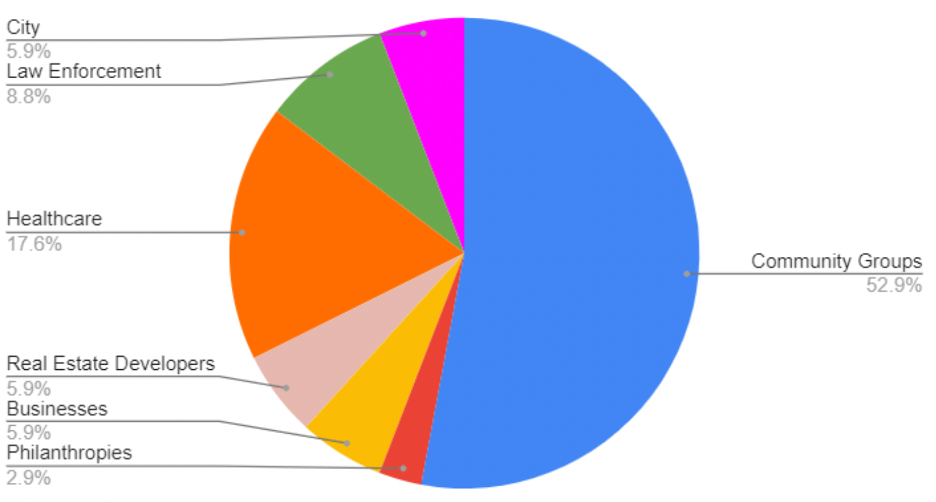
This approach to crime prevention focuses on places, not people. It democratizes data and analytics. Multiple community organizations are empowered to become co-producers of public safety. The NPSC hosts monthly meetings with a large and diverse group of local stakeholders, which includes city officials and police, but mostly others such business owners, non-profit organizations and community groups. They all get access to the same data and analytics, add context to it, then form strategies to disrupt the risk narratives at priority places based on their own unique missions, resources and expertise. Their independent initiatives combine to produce a deliberate and impactful response to crime problems throughout the city as a whole. The result is a comprehensive, dynamic, transparent and effective crime prevention strategy tailored to the local problem. Law enforcement is only one part of the effort.
In another example focused on aggravated assault, maps showed high-risk locations to deploy resources, and other information detailed what to focus on when they got there. Police directed patrols to priority places, and other city services addressed abandoned buildings and vacant lots at these locations.
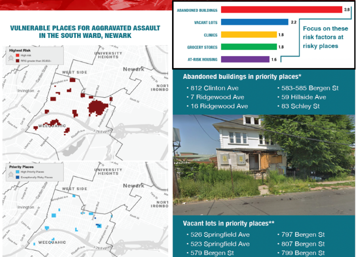
But also, New Community Corporation used this info for their site suitability analysis to purchase and remediate abandoned properties and improve access to affordable housing. The South Ward Children’s Alliance and Newark Community Solutions teamed up to adopt city-owned vacant lots in high-risk places and turn them into useable, maintained, spaces with library boxes, stages, murals. The Newark Community Street Team deployed outreach workers to the highest-risk places to help ensure safe passage for children walking to and from schools.
This and other programs based on the NPSC model have proven to reduce violent and property crimes by as much as 40%. And the impact is long-lasting.
You can do this too, and you probably already have the resources to be successful! What’s needed is to differentiate between law enforcement and public safety, and to think differently about crime prevention. It’s not about selecting just one strategy. It’s about the PROCESS for data sharing and problem-solving with inputs and actions from many stakeholder perspectives. The process is the strategy! NPSC makes this process of data-informed community engagement structured and repeatable.

Ready to become an OPS Plus Partner?
Cick the below button to begin the process of claiming your agency’s OPS Network and become an OPS PLUS Partner.
About
OPS Overview
Resources
")

")
© 2026 Online Policing Solutions, Inc. All Rights Reserved